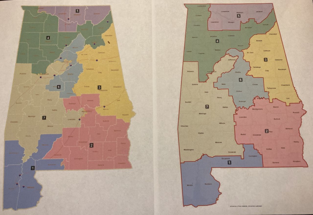
Which counties moved on Alabamaâs congressional map?
The new congressional district map approved Friday by the Alabama Legislature makes changes to all seven districts and moves about a dozen counties to different districts.
Democratic lawmakers denounced the plan and said it would not fix the likely Voting Rights Act violation found by a three-judge federal court and affirmed by the U.S. Supreme Court.
Republicans, who hold three-fourths of the seats in the Legislature, approved the map by a 24-6 vote in the Senate and 75-28 in the House. They praised the plan for its compactness and said it kept together communities of interest, which they said included Mobile and Baldwin counties on the coast, the Black Belt, and the Wiregrass.
Democrats said the plan failed to address the key finding by the court, the need to create a second majority Black district, or, as the court said, “something quite close to it.”
District 7 remains the only majority Black district, with a Black voting age population of 51%. The Black voting age population in District 2 increased from 30% to 40%. Republicans said that would comply with the court guidance to create a second district where Black voters would have an opportunity to elect a candidate of their choice.
Democrats disputed that and said they will rely on the federal court to reject the plan.
Friday was the deadline set by the three-judge district court for the Legislature to pass a new map. The court’s deadline was based on guidance from state officials about when a map would have to be ready in time for next year’s elections.
The court said the Black voters and organizations who are plaintiffs in the litigation should file their objections by July 28. The court has tentatively scheduled a hearing on challenges to the plan to begin on August 14.
The court said the Black voters and organizations who are plaintiffs in the litigation should file their objections by July 28.
A summary of some of the changes:
District 1, in southwest Alabama, still includes all of Baldwin and Mobile counties. The district became wider and flatter, losing Washington and Monroe counties on its north side and gaining most of Covington County on its east side.
District 2 still covers southeast Alabama but changed substantially. It added Lowndes, Macon, and Russell counties. It added northwest Montgomery County and now includes all of that county. It lost Autauga and Conecuh counties, most of Covington, and about half of Elmore.
District 3 in east Alabama also changed substantially. It lost Macon, Russell and Coosa counties and gained Etowah.
District 4 still spans the state from east to west in the northern half of the state. It lost Etowah County and added Blount County.
District 5, which spans most of the border with Tennessee, gained Lawrence County and lost a portion of Lauderdale County.
District 6 in central Alabama gained Coosa and Autauga counties and lost Blount County.
District 7 in west Alabama added Washington, Monroe, and Conecuh counties on the south end and lost Lowndes County.
